Discover RTA's Ongoing Projects
Welcome to the RTA Projects Showcase, where we highlight our key infrastructure and transportation initiatives driving Dubai’s progress. Our projects are designed to enhance connectivity, reduce travel times, and support the city’s rapid growth in addition to reflecting Dubai Government 2040 vision. Explore our range of ongoing projects that aim to provide efficient, sustainable transportation solutions for residents and visitors alike as well as enhance the quality of life.
3 Integrated Truck Rest Areas

Project Description
- Spans a total area of over 210,000 square metres
- It has the capacity for 490 trucks and heavy vehicles.
- The development is in partnership with the private sector.
- The project is in: Jebel Ali, Saih Shuaib, near the entrance to Dubai Industrial City (DIC), and in Madinat Hind 2 along Emirates Road, adjacent to Al Tayy Racetrack.
Project Benefits
- Enhances the efficiency of the land transport sector and reinforces the emirate’s position as a global hub for trade and logistics services.
- Enhances road safety by providing an integrated and secure environment for drivers, thus helping in reducing random stopping and improving traffic flow across the road network.
- Strengthens the freight and logistics sector, which is a strategic pillar and core enabler of the Dubai Economic Agenda D33.
Phase One – Development of Historic Al Ras

Project Description
- The development of the Historic Al Ras Walkway, comprising 12 km of walkways.
- The development of 5 km cycling tracks.
- The rehabilitation of 10 artistic spaces in coordination with Dubai Culture and Arts Authority, with the participation of Emirati and local artists.
Project Benefits
- Advances a key objective of the Dubai Urban Plan 2040, the 20-minute city, by providing the infrastructure required to enable residents to access more than 80% of essential services within a 20-minute journey.
- Supports Dubai’s Quality of Life Strategy 2033 and contributes to enhancing community wellbeing by transforming Dubai into a pedestrian-friendly city, elevating pedestrian safety standards.
- Strengthens connectivity between various districts and the existing walkway network.
- Integrates creative, aesthetic and cultural dimensions into soft mobility components, reinforces the distinctive identity of urban areas to enhance the emirate’s visual landscape.
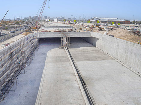
Phase Two of the Development of Hessa Street

Project Description
- The project spans the 3 km corridor between Al Khail Road and Sheikh Mohammed bin Zayed Road.
- It includes upgrading three major intersections by constructing bridges extending 8,835 metres and a 480-metre tunnel.
- Includes upgrading Al Khail Road–Hessa Street interchange through expanding Hessa Street from two lanes to four lanes in each direction.
- Includes the construction of a 525-metre, two-lane braided ramp to eliminate traffic overlap between Al Khail Road and Al Khamila Street.
Project Benefits
- It serves 10 residential and development areas and benefits approximately 650,000 residents, including Jumeirah Village Circle (JVC) and Al Barsha South.
- Increases the road capacity for Hessa Street by 100%.
- Reduces the journey time from 24 minutes to five minutes.
Dubai Loop Project

Project Description
- A network of innovative underground tunnels for passenger transport across the emirate, using advanced technologies.
- The first phase of the project involves the development of a 6.4 km route with four stations, linking the Financial District with Dubai Mall, paving the way for the project’s full alignment, extending up to 22.2 km.
- Includes 19 stations, connecting the Trade Centre and Financial Districts with the Business Bay area.
Project Benefits
- Improves the mobility system and enhances efficiency and traffic flow in high-density urban areas
- Supports first- and last-mile journeys, with rapid implementation, cost efficiency, and minimal impact on existing roads and utility services.
Glydways Project

Project Description
- The first automated programme for an Autonomous Transit Network.
- Glydways vehicles accommodate four to six passengers and operate on electric power, offering a range of up to 250 km per charge and speeds of up to 50 km/h.
- Represents a next-generation transport system based on autonomous electric vehicles.
Project Benefits
- Supports the public transport network and delivers efficient first- and last-mile solutions.
- Operates on narrow, dedicated guideways independent of road traffic.
- Reduces capital costs by up to 90% and operating costs by up to 70% compared with other transport modes.
Bridge Project Leading to Dubai Harbour

Project Description
- It is part of the 1,500-metre bridge project featuring two lanes in each direction.
- Completing 90% of works related to upgrading and adjusting utility services intersecting with the project, alongside the implementation of approved traffic diversions.
- It extends from Interchange 5 on Sheikh Zayed Road, near the American University in Dubai, passing through the intersection of Al Naseem Street and Al Falak Street, and crossing over King Salman bin Abdulaziz Al Saud Street, before connecting to Dubai Harbour Street.
Project Benefits
- Provides direct entry and exit access from Sheikh Zayed Road to Dubai Harbour.
- The project provides a total capacity of approximately 6,000 vehicles per hour.
- Enhancing the development of the area as a landmark waterfront destination that hosts the largest yacht marinas in the Middle East.
Oud Maitha Road and Al Asayel Street Development

Project Description
- It is part of the Sheikh Rashid Corridor Development Project.
- The scope includes the development of four major intersections: Oud Maitha Road–Sheikh Rashid Road intersection. It also includes the addition of a left-turn slip ramp for traffic coming from Oud Maitha Road onto Sheikh Rashid Road towards Al Garhoud Bridge.
- Includes the construction of bridges spanning 4.3 km and roads extending 14 km.
Project Benefits
- Enhances connectivity between Al Asayel Street and Al Khail Road.
- Increases the capacity of Oud Maitha Road by 50%.
- Increases the capacity of vehicles and traffic movements at the intersections serving the project.
Sheikh Zayed bin Hamdan Al Nahyan Street Intersection Development with Al Awir Road and Al Manama Street

Project Description
- The construction of 2,300 metres of bridges with the expansion of lanes.
- The paving of service roads along Sheikh Zayed bin Hamdan Al Nahyan Street and Al Awir Road in both directions.
- The provision of entrances and exits serving residential and development areas along the corridor.
- Completion is expected in the third quarter of 2028.
Project Benefits
- Increases the street’s capacity from 5,200 vehicles per hour in both directions to 14,400 vehicles per hour in both directions—an increase of 176%.
- Reduces travel time from 20 minutes to just five minutes.
- Serves residential and development areas with a combined population of residents and visitors exceeding 600,000.
6 New Pedestrian and Cyclist Bridges Across Major Roads

Project Description
- Five of these bridges are scheduled to open before the end of 2025, with the sixth set for completion in the first quarter of 2027.
- Two pedestrian and cyclist bridges on Sheikh Zayed Road and Al Khail Road.
- The third bridge is located on Al Manara Street in Al Quoz Creative Zone.
- The fourth bridge is located on Sheikh Mohammed bin Zayed Road at its intersection with Tunis Street – Al Nahda.
- The fifth bridge was situated on the Dubai–Al Ain Road.
- The sixth pedestrian bridge is under construction as part of the Future Street Improvement Project on Al Sukook Street.
Project Benefits
- Enhances road safety and provides a safe and sustainable mobility environment for all road users.
- Transforms Dubai into a pedestrian and cyclist-friendly city and supports the city’s quality of life agenda.
- Providing a network of routes that connects residential areas in the Emirate of Dubai with major attractions, to encourage residents to use sustainable individual transportation for first- and last-mile journeys.
Construction of Internal Roads in 8 Residential and Industrial Areas

Project Description
- The total length of roads is 103 kilometres.
- The areas are: Al Khawaneej 2 (Tolerance District), Jebel Ali Industrial Area 1, Nad Al Sheba 1, 3 and 4, Al Awir 1, Wadi Al Amardi, and Al Warqa’a.
- Providing roadside parking spaces, lighting poles, dedicated ycling lanes, and signalised intersections, in addition to the development of entrances and exits, and upgrading the stormwater drainage networks.
- Constructing pedestrian pavements and parking spaces near key community facilities.
Project Benefits
- Enhancing traffic flow for thousands of vehicles per hour.
- Increasing the capacity for vehicle movement.
- Meeting the needs of growing traffic volumes.
- Addressing the requirements of urban and population growth.
Widening the Bridge Leading to Terminal 1 of Dubai International Airport

Project Description
- Widening the existing bridge from three to four lanes
- Constructing a new bridge using an innovative system of steel box girders integrated with a composite concrete slab.
- The total length of the bridge, including its ramps, is 171 metres, with the main span extending nearly 70 metres.
Project Benefits
- Increases the bridge’s capacity from 4,200 to 5,600 vehicles per hour, a 33% increase.
- It is part of RTA’s continuous efforts to improve traffic flow and strengthen connectivity between major corridors and vital facilities, most notably Dubai International Airport.
Upgrading Waiting Areas at 5 Marine Transport Stations

Project Description
- It is part of the second phase of the project to upgrade waiting areas at marine transport stations.
- This phase covers five key stations: Al Fahidi, Baniyas, Al Seef, Sheikh Zayed Road, and Bluewaters.
- It includes the installation of advanced air-conditioning systems, designated waiting areas for customers and People of Determination.
Project Benefits
- This project forms part of RTA’s master plan to enhance the infrastructure of the marine transport network in Dubai and raise the quality of services provided in this sector.
- It aligns with the vision of the Government of Dubai to deliver world-class services to residents, tourists, and visitors.
- It contributes to smoother mobility for residents and visitors, reduces reliance on private vehicles, and ensures seamless intermodal connectivity across Dubai’s public transport system.
Al Mustaqbal Street Development
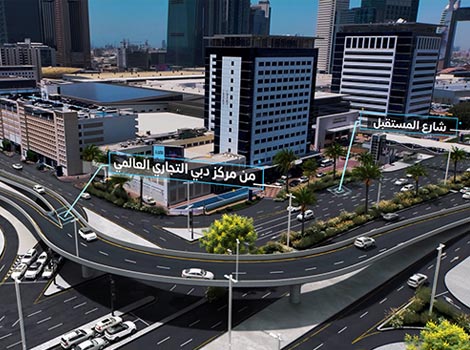
Project Description
- The project extends from the intersection with Za’abeel Palace Street to Financial Centre Street.
- Includes the construction of a 450-metre, two-lane bridge and three tunnels totalling 1,200 metres.
- Expanding the street from three to four lanes in each direction.
- Al Mustaqbal Street Development Project forms part of a master plan that includes the Development of the Trade Centre Roundabout.
Project Benefits
- Increases the corridor’s capacity by 33%, from 6,600 to 8,800 vehicles per hour in both directions.
- Reduces travel time from 13 minutes to 6 minutes.
- Serves the Dubai World Trade Centre, as well as Za’abeel, Downtown Dubai, and Business Bay areas.
- Expected to benefit approximately half a million residents and visitors.
Al Safa Street Improvement from Sheikh Zayed Road to Al Wasl Street Intersections
Project Description
- The project spans 1,500 metres.
- It involves the construction of two bridges and two tunnels with a combined length of 3,120 metres.
- Widening of surface roads and upgrading the intersections and traffic signal systems.
- It is part of RTA’s master plan to enhance the road network in the area, which also includes the development of Umm Suqeim and Al Wasl Streets.
- It includes the development of dedicated pedestrian walkways and cycling tracks, vibrant urban spaces and the integration of a dynamic public realm enhanced by landscaped areas.
Project Benefits
- Reduces travel time on Al Safa Street from 12 minutes to just 3 minutes.
- Doubles the street’s capacity from 6,000 to 12,000 vehicles per hour in both directions.
- Serves a vital district renowned for hosting numerous tourism, cultural, and sporting events.
Expansion of Burj Khalifa/Dubai Mall Metro Station
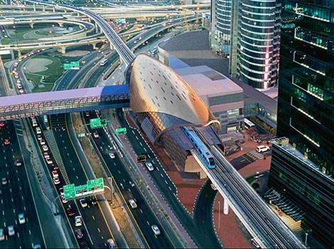
Project Description
- The station’s area will expand from 6,700 to 8,500 square metres, registering a 65% rise.
- Enhancing entrances and pedestrian bridges to facilitate access.
- Expanding concourse and platform areas, installing additional escalators and elevators, and separating entry and exit gates to optimise passenger movement.
- Increasing the number of fare gates and expanding commercial spaces to boost revenue.
Project Benefits
- Accommodates the increasing growth in the number of station users, especially during New Year’s celebrations, holidays, special occasions, and national vacations.
- Will serve up to 220,000 passengers per day.
The Development of Al Wasl Road
Project Description
- The development spans 15 km, from the intersection with Umm Suqeim Street to the junction with 2nd December Street.
- It includes the upgrade of six intersections, comprising enhancements to one junction and the construction of five tunnels totalling 3,850 metres.
- It includes widening the street from two to three lanes in each direction.
Project Benefits
- Reduces travel times along Al Wasl Road by 50% .
- Increases the capacity from 8,000 to 12,000 vehicles per hour in both directions.
- Keeps pace with the needs of urban development and population growth, enhances the traffic flow, and contributes to the quality of life for residents and visitors of Dubai.
Integrated Urban Project to Upgrade Umm Suqeim Street

Project Description
- Upgrading Umm Suqeim Street starts from its intersection with Jumeirah Street to Al Khail Road.
- It complements the works currently underway to upgrade Umm Suqeim Street from its intersection with Al Khail Road to Emirates Road.
- The project entails the upgrade of six key intersections along Umm Suqeim Street, specifically those with Jumeirah Street, Al Wasl Street, Sheikh Zayed Road, First Al Khail Street, Al Asayel Street, and Al Khail Road
- The scope includes the construction of four bridges and three tunnels, with a total combined length of 4,100 metres.
- Includes the construction of two bridges intersection with Sheikh Zayed Road.
Project Benefits
- This corridor serves key residential and development zones with a combined population exceeding two million.
- Enhances connectivity across four strategic transport corridors in Dubai: Sheikh Zayed Road, Al Khail Road, Sheikh Mohammed bin Zayed Road, and Emirates Road.
- Increases Umm Suqeim Street’s capacity to 16,000 vehicles per hour in both directions.
- Reduces travel time between Jumeirah Street and Al Khail Road from 20 minutes to just six.
Achieving 70% of Umm Suqeim Street Improvement Project
Project Description
- This achievement spans 4.6 km from the intersection with Al Khail Road to the intersection with Sheikh Mohammed Bin Zayed Road.
- It is part of a master development plan for Umm Suqeim–Al Qudra corridor, which runs from Jumeirah Street to Emirates Road, spanning 16 km in total.
- The Umm Suqeim–Al Qudra Corridor Improvement Project is one of the key strategic transverse (east-west) traffic corridors, designed to enhance integration with vertical (north-south) road corridors.
Project Benefits
- Serves several residential and development areas with a population exceeding one million residents.
- Improves connectivity between four major arterial roads in Dubai: Sheikh Zayed Road, Al Khail Road, Sheikh Mohammed Bin Zayed Road, and Emirates Road.
- Increases the corridor’s capacity to 16,000 vehicles per hour in both directions, improves traffic flow, and reduces travel time between Sheikh Mohammed Bin Zayed Road and Al Khail Road by 61% from 9.7 minutes to just 3.8 minutes.
A 700-Metre Bridge Connecting Dubai–Al Ain Road to Nad Al Sheba
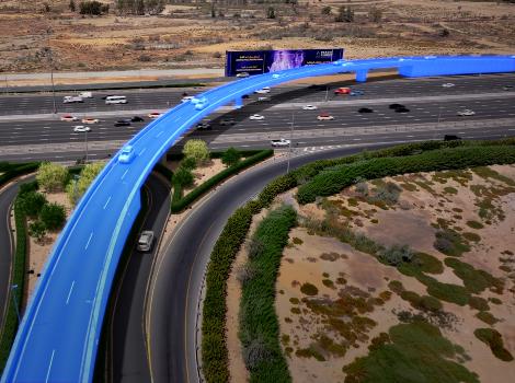
Project Description
- Construction of the new bridge is scheduled to begin in the fourth quarter of 2025, with completion targeted for the fourth quarter of 2026.
- It spans 170 metres and features two lanes in each direction.
- It leads to residential areas in Nad Al Sheba and provides direct connection for inbound traffic from Dubai–Al Ain Road towards Al Ain.
- It has the capacity 2,600 vehicles per hour.
- It is part of RTA’s strategic direction to achieve safer and more efficient mobility.
Project Benefits
- Reduces travel time from Dubai–Al Ain Road to Nad Al Sheba by 83%, cutting the journey from six minutes to just one.
- Enables smooth and efficient traffic flow for an area home to around 30,000 residents.
- Supports the strategy of introducing sustainable and proactive traffic solutions for mobility in Dubai.
Bridges Connecting Dubai Islands to Bur Dubai
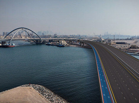
Project Description
- It includes the construction of a bridge over Dubai Creek, between the Infinity Bridge and Port Rashid Development area.
- The bridge spans 1,425 metres, with four lanes in each direction.
- It rises 18.5 metres above the surface of Dubai Creek.
- It is part of Al Shindagha Corridor Development Project, one of RTA’s key strategic road projects.
- It includes a dedicated pedestrian and cycling track connecting both ends of the bridge.
Project Benefits
- Accommodates a total capacity of 16,000 vehicles per hour in both directions.
- Allows various types of vessels to pass through the Creek.
- Significantly improves access to Dubai Islands.